Expanding Blue Space Benefits Through Coastal Resilience
We are undeniably drawn to coastlines. We seek them out as our top vacation destination. According to Sustainable Travel International, 80% of all tourism takes place in coastal areas. We also like to call them home. NOAA estimates that coastal counties are home to almost 40 percent of the total population of the contiguous US while accounting for less than 10 percent of its land mass.
We instinctively know that having access to water and blue space is good for us. It encourages outdoor and physical activity and helps us unwind and reconnect. But there is a growing body of research and evidence that suggests engaging with water yields a far wider range of physical and psychological benefits than we previously thought.
The late marine biologist and author Wallace Nichols called the state of calm that people reach when they’re in or near water as having a “blue mind.” In his book of the same name, he lays out “The Surprising Science That Shows How Being Near, In, On, Or Under Water Can Make You Happier, Healthier, More Connected, and Better at What You Do.” Numerous studies indicate that just viewing water provides invaluable health and wellness benefits. It’s increasingly common to see health organizations like Scripps Health recommending a visit to the water as a prescription for patient wellbeing.
The Challenge of Privatized Blue Space
While the health benefits of blue spaces are universal, access to them is not. Waterfront land in the U.S. is highly valued for commerce and individual ownership, frequently leading to restricted use.
The ratio of private vs. public ownership of waterfront land varies throughout the U.S., but it is typical for 60-70% of a state’s coastal land to be privately owned. According to the Great Lakes Stewardship Initiative, roughly 80% of the U.S. Great Lakes freshwater coastline is privately owned. This contrasts sharply with only 20% in the Canadian Great Lakes region.
The limits posed by private ownership of waterfront property are frequently compounded in communities with “resident only” policies for their few public access points, as well as legacies of segregated development practices. While walkable access to quality greenspace is frequently evaluated as a key consideration for equitable communities, public access to blue space hasn’t gotten the same level of attention. But increasing recognition of blue-space disparities has led organizations like the Natural Resources Defense Council to identify coastal access as an environmental justice issue.
Ohio’s Resilient Solution
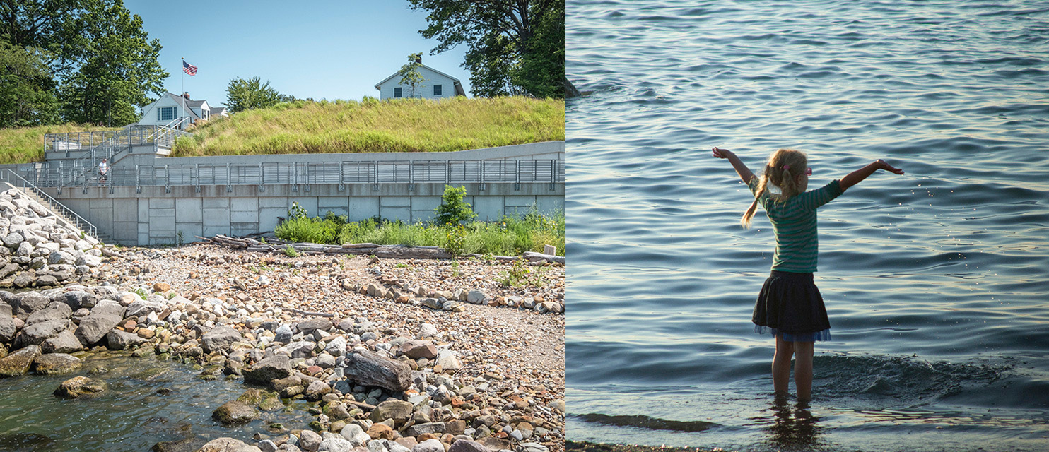
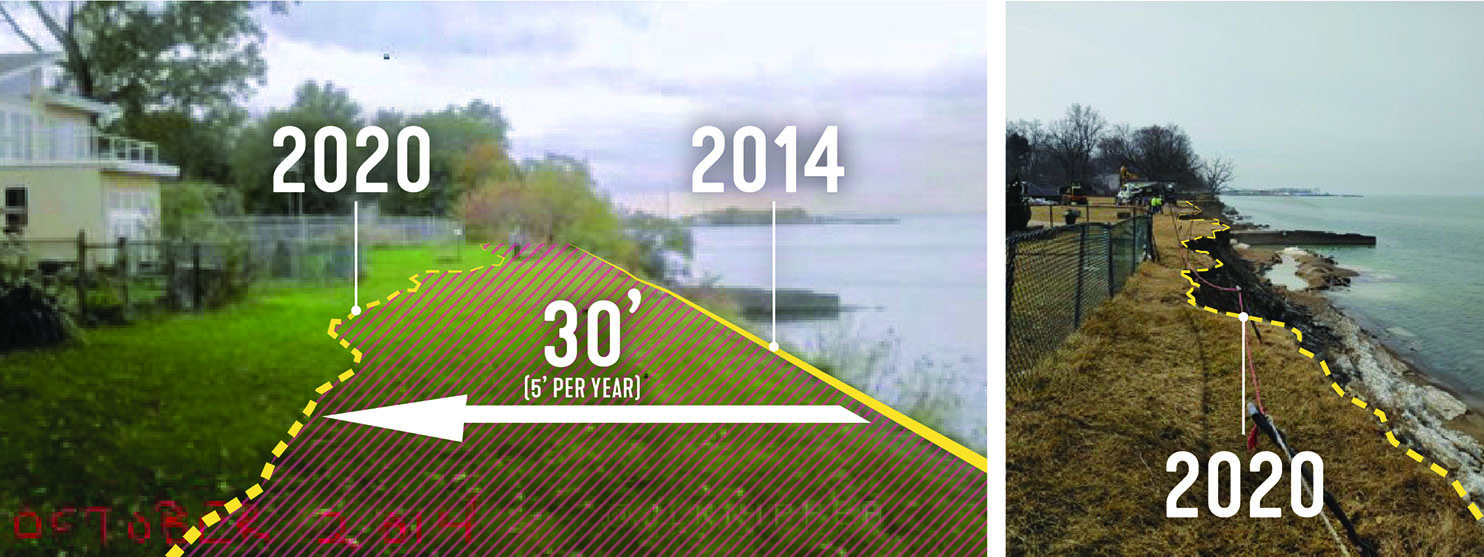
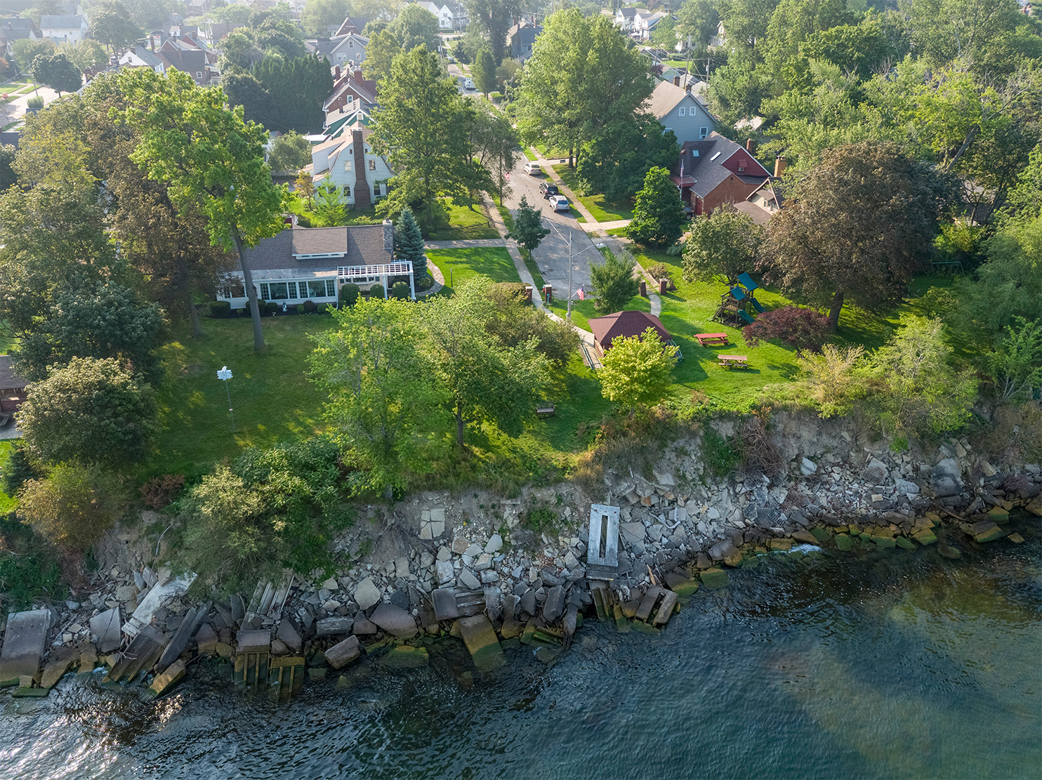
In 2010, SmithGroup started working with the City of Euclid, Ohio to forge a new path for protecting its Lake Erie waterfront while reconnecting their community to it. Euclid’s formerly wide, protective beaches had eroded to almost nothing. The city’s lakefront landowners were facing severe and accelerating erosion threats to the bluffs supporting their homes, multiresidential buildings and infrastructure. On top of this, only 6% of the city’s nearly 5-mile lakefront was publicly owned and accessible, making it harder to address the problems at scale.
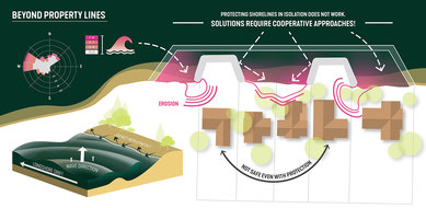
Euclid recognized the costs of shoreline protection were too great for individual property owners to bear - and that the forces of wind, waves, ice and erosion don’t respect property lines. Segmented investment in coastal protection was doomed to fail, since any break in the chain endangers the protected areas next to it.
Euclid’s Waterfront Improvement Plan laid out a first-of-its-kind strategy that provided publicly funded shoreline protection in exchange for the signing of private easements allowing for public lakefront access. Knowing we couldn’t stabilize the bluffs from the top down physically or politically, we committed ourselves to many months of face-to-face conversations in landowners’ backyards and living rooms. This allowed us to address their safety and security concerns and to build rapport and trust for a resilient solution.
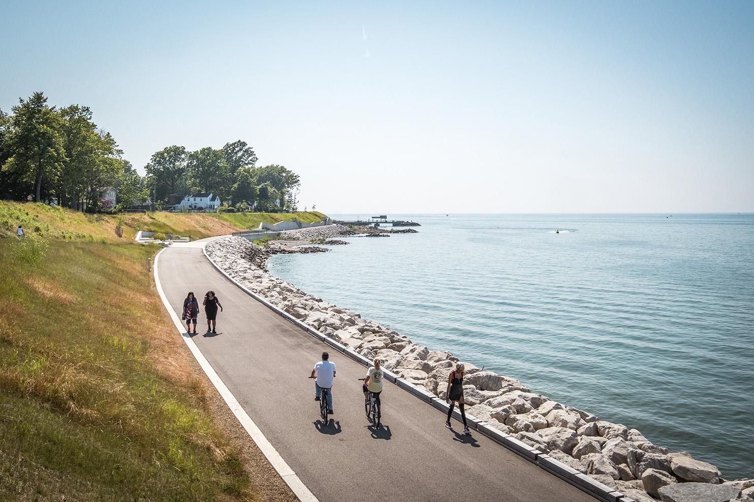
Ultimately the concerns over extensive erosion occurring in real time and the potential for shared, affordable protection carried the day. Over 100 property owners signed on for the first 1-mile phase. The project was also able to secure millions of dollars in local, county, state and federal grant funding due to its multitude of community benefits. As a result, Euclid increased public access from 6% to nearly 20% of its lakefront, dramatically expanding blue space benefits for the community and establishing a new precedent for others to emulate.
In response to the success of “the Euclid model,” Cuyahoga County decided to build on it. Ohio’s Cuyahoga County shoreline spans 32 miles of Lake Erie and connects six municipalities – including Euclid and Cleveland. Nearly 90% of that shoreline (consisting of a little over 3,800 properties) is privately owned in a county with a population of approximately 1.24 million people. Only about 12% of the shoreline is publicly accessible at various lakefront parks scattered throughout the county.
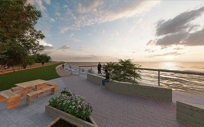
Working with SmithGroup, the County recently completed its Lakefront Public Access Plan: an award-winning strategy that has the potential to increase public lakefront access to 50% of the County’s shoreline. While still in its early stages of implementation, the potential blue-space access, equity and resilience benefits are staggering.
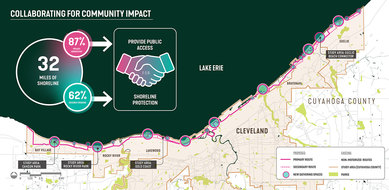
62% of Cuyahoga County’s lakefront is severely eroding. The plan’s public/private partnership framework will help address this erosion at scale while dramatically increasing public access.
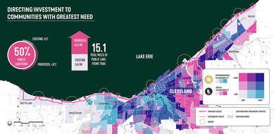
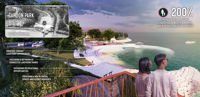
Implementation will result in a 44% increase of county residents within a 10-minute walk to accessible blue space, including a 200% increase in low-income households.
A significant increase in equitable access to vibrant waterfront parks is a hallmark of the plan.
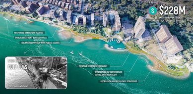
The plan will also prevent the potential loss of an estimated $228 million in property and infrastructure currently at risk from severe shoreline erosion.
A Replicable Model for Resilient Blue Space Benefits
Numbers only tell part of the story, but they’re compelling. Before phase one construction started, Euclid’s Sims Park saw roughly 70,000 annual visitors. Following completion in 2021, visitation increased to 160,000 per year - with 2,837 additional city residents located within a 10-minute walk to the expanded public lakefront.
The anecdotal evidence is equally compelling. A resident at the grand opening said, “I know I invested in the right community because the community is investing in me.” A family from Chicago came to the lakefront because their friends said it was a “must see.” And the problems with trash and graffiti that some were expecting have not materialized. Instead, as people walk down to the new cobble beaches, many leave behind personal pathways they shaped with the stone.
Shoreline loss is a nearly ubiquitous condition on the Great Lakes and along U.S. saltwater coasts – especially with the increasing threat of sea-level rise. If there is a silver lining to the complexity of challenges facing our coastlines, it is the civic motivation it provides to engage and collaborate across property and jurisdictional lines to find shared solutions. Our work in Euclid and Cuyahoga County establishes a transferable model for how improved coastal resilience and equitable access can extend the health and wellness benefits of blue space and the blue mind to hundreds of thousands of people.