Cuyahoga County Lakefront Public Access Plan

By pairing erosion control with expanded public access, an ambitious and unconventional shoreline restoration project ensures a healthier Lake Erie lakefront for all.
Client
Cuyahoga County Planning Commission
Location
Cleveland, Ohio
Markets/Services
Civil Engineering, Landscape Architecture, Greenways & Trails, Parks & Promenades, Shoreline Protection & Restoration, Urban Planning, Waterfront, Waterfront Plans
Featured Awards
Fast Company World Changing Ideas Awards - Honorable Mention, 2024
Situated along northeast Ohio’s Lake Erie shore, Cuyahoga County is the state’s second most populous county, home to the city of Cleveland. Yet nearly 80 percent of the shoreline in the county is privately owned and inaccessible to the public. In addition, wave action was rapidly eroding the shoreline, degrading habitat, and threatening buildings and infrastructure. County leaders looked to expand upon an earlier SmithGroup project within the county that created a unique public-private partnership model successfully addressing both issues.
The Lakefront Public Access Plan covers the entire 32-mile Lake Erie shoreline within Cuyahoga County and dovetails two key initiatives: stabilizing severely eroding shoreline while expanding public access to Lake Erie for all its residents. The plan works in conjunction with lakefront landowners willing to grant easements for a public lakefront trail in exchange for erosion control provided largely by government funds and grants. Achieving social, ecological and economic benefits, this unconventional plan will increase public access to the lakefront by 50 percent—more than 300 percent outside downtown Cleveland—most notably among typically underserved communities in the Metro area.
The scale of the project was daunting. With more than 3,800 lakefront property owners in the county, the project began with extensive outreach efforts to determine opportunities for public-private partnerships.
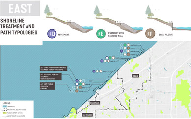
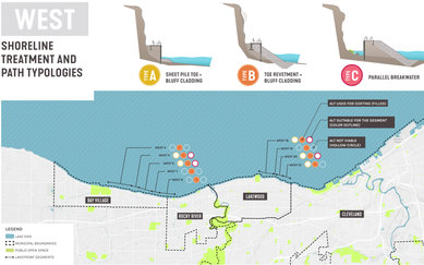
At the same time, the team evaluated the entire 32 miles of shoreline against four key objectives: expanding public access, protecting natural resources, enhancing habitat, and promoting economic investment. Using geospatial tools and analytics, the plan identified three initial priority areas where needs were greatest, objectives could be met, and owners were receptive.
Implementation of these trail segments has gained momentum and landowner support continues to grow. Currently, more than $6.4 million in grant funding has been secured and permitting is underway for initial phases of construction, as well as an estimated $228 million property and infrastructure loss has been avoided. With a proposed 8.3 miles of new lakefront access, the LPAP identifies new public lakefront access along 50% of the countywide shoreline, supporting a more equitable distribution of lakefront access, and defines a continuous east-west lakefront route.
Supporting a more equitable distribution of lakefront access and experiences that involve the lake creates opportunity for the 3,950 new residents under the age of 18 to engage with the lake within 10 minutes of where they live.
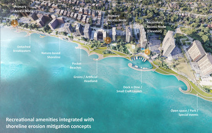
Key to the plan’s success, the shoreline trail design balances the needs of public and private stakeholders. The linear trail runs largely midway down 30- to 50-foot bluffs, which gives direct and convenient public access to the lake while remaining largely unobtrusive to landowners. The measures employed to protect the shoreline and restore habitat—including sand beaches, cobble beaches, and rain gardens—also become attractive amenities for landowners and the public.